
The best and only wind-forecast for the northern part of Lake Garda.
Windy, Windguru, Windfinder etc. are pointless to use for wind prediction on Lake Garda.
To obtain a relative secure forecast for the coming days please refer to the charts below.
Another great tool for wind, rain and clouds is the App from METEOSWISS. Inside the App navigate to Animations. Download for Android / Apple.
For the current water temperature please see the Webcam of Campione here. You can find all Webcams here.
To know the live windspeed in front of our center with northwind please take the average between the Webcam of Limone and Malcesine.
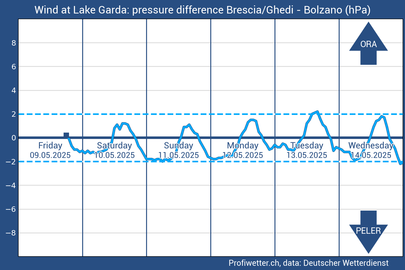
Pressure Chart
The strength of Peler and Ora can be determined by the pressure difference (in hecto-pascal [hPa]) between Bolzano and Brescia / Ghedi. Ora occurs as soon as Brescia / Ghedi has higher air pressure than Bolzano. The larger this pressure difference, the stronger the Ora blows over the northern Lake Garda. At the opposite pressure difference (low air pressure in Brescia / Ghedi and high air pressure in Bolzano) the opposite north wind blows Peler.
The wind diagram shows a prediction of the pressure differential (Bolzano - Brescia / Ghedi) for the following five days. The forecast is based on MeteoGroup's statistical forecasting method MOS and is updated every hour.

Cosmo 2
This limited area model has a spatial resolution of about 2 km and a temporal resolution of 1 hour. The model successfully forecasts the winds of the Garda breeze (òra and pelèr). This page shows the forecast of the model (without intervention of the forecaster) relative to average hourly speed expressed in meters per second (in red) and average hourly wind direction (black arrow).
The climate is sub-Mediterranean due to the location, with hot summers and low precipitation, mild winters.
The annual average temperature ranges from 13 -15 ° C. In Gardone Riviera, on the southwestern shore of the lake, the mildest climate prevails north of the Apennines. The main winds on the northern lakes are the Ora and the Peler.
The Ora is a southerly wind, which starts at noon and blows until the early evening hours. The Pelér (also known under the name Vento (ital. for wind) is a north wind, which begins in the second half of the night and continues until late morning. Due to these winds of the northern Lake Garda between Torbole and Malcesine is very popular with sailors and surfers.
Caution
When in summer an early morning light south wind picks up, the so called "bad-weather Ora" or as the local fishermen call it: "Vent de temporal" (in Torbole it can reach 6-7 Bf.) it will certainly rain before sunset. When the wind dies out the strong rainfall and low temperature can generate the Bali in the evening. When in the afternoon, in normal weather conditions or when clouds pass the northern mountains, and the Ora has calmed down, then in the shortest of time, depending on the temperature drop, the Peler or Bali can form. With low sunrays these winds become stronger and hold until 2 pm. the next day..


Ora
The most famous Garda wind blows from south to north and builds itself from many smaller winds that meet between Gargnano and Brenzone to form the ora. It's quite regular in spring, summer and autumn. Stronger and most reliable in summer because it uses the strong sunrays reflected from the water and the mountains around the northern part of the lake. The Ora starts when the Peler drops between 12 and 1.30 pm. and ends, in normal conditions, at sunset. Its wind force varies considerably, for example: in Brenzone 1-2, in Campione 3-5, in Malcesine 2-4 and in Torbole 4-5 Beaufort the further up the lake it blows the stronger it gets
Peler
It's the King of all Lake Garda winds, a "good-weather" wind. It's constant and steady in the months of June, July, August & September, and starts between midnight and 3 am.
A characteristic of the Peler are three big waves, the biggest of these three is the second that is ideal for windsurf acrobatics.
Bigger waves are to be found a little more south near Torri del Benaco and even bigger near Toscolano.
The Peler lasts about 12 hours, but if it builds up stronger than its usual 4/5 Beaufort, then it can last until 2 or 3 pm. It brings strong waves and stirs up the deep cold water from the depth of the lake bringing the water temperature down, so delaying the Ora wind to develop. In the late afternoon the water turns flat and a strong current conveys the water back north past Brenzone, Malcesine & Navene. Later in the evening the north wind builds up again.